Only clear skies on Google Maps and Earth
To celebrate the sunny days of summer (in the northern hemisphere at least), today we're launching new satellite imagery for Google’s ma...
https://iskablogs.blogspot.com/2013/06/only-clear-skies-on-google-maps-and.html
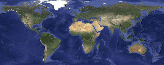
To celebrate the sunny days of summer (in the northern hemisphere at least), today we're launching new satellite imagery for Google’s mapping products. This stunning global view is virtually cloud-free and includes refreshed imagery in more locations—giving you an even more accurate and comprehensive view of our planet's landscape.
Our satellite imagery is usually created like a quilt: we stitch together imagery of different parts of the world. Using a process similar to how we produced the global time-lapse imagery of the Earth, we took hundreds of terabytes of data from the USGS's and NASA’s Landsat 7 satellite—sometimes dozens of photos of a single spot in the world—and analyzed the photos to compute a clear view of every place, even in tropical regions that are always at least partly cloudy.
The result is a single, beautiful 800,000 megapixel image of the world, which can be viewed in Earth and Maps when you're zoomed out to a global view. This global image is so big, if you wanted to print it at a standard resolution of 300 dots per inch you’d need a piece of paper the size of a city block! This image is then blended into our highest resolution imagery, giving a beautiful cloud-free global view and detailed images in the same seamless map.
This update also includes refreshed imagery in many regions of the world, especially in areas where high-resolution imagery is not available, including parts of Russia, Indonesia and central Africa.
You can see the new satellite imagery by going to Google Maps and turning on satellite view, or by opening Google Earth, and zooming out. And to read more about what went into creating this imagery, check out our detailed post on the Lat Long blog. Have fun exploring!
The new, even more beautiful global view in Maps and Earth.
Our satellite imagery is usually created like a quilt: we stitch together imagery of different parts of the world. Using a process similar to how we produced the global time-lapse imagery of the Earth, we took hundreds of terabytes of data from the USGS's and NASA’s Landsat 7 satellite—sometimes dozens of photos of a single spot in the world—and analyzed the photos to compute a clear view of every place, even in tropical regions that are always at least partly cloudy.
The result is a single, beautiful 800,000 megapixel image of the world, which can be viewed in Earth and Maps when you're zoomed out to a global view. This global image is so big, if you wanted to print it at a standard resolution of 300 dots per inch you’d need a piece of paper the size of a city block! This image is then blended into our highest resolution imagery, giving a beautiful cloud-free global view and detailed images in the same seamless map.
Central Papua, Indonesia: before and after.
This update also includes refreshed imagery in many regions of the world, especially in areas where high-resolution imagery is not available, including parts of Russia, Indonesia and central Africa.
Saudi Arabia: before and after, showing increased agricultural expansion
You can see the new satellite imagery by going to Google Maps and turning on satellite view, or by opening Google Earth, and zooming out. And to read more about what went into creating this imagery, check out our detailed post on the Lat Long blog. Have fun exploring!


